3D Stereoscopic Sensor on “DAICHI (ALOS)”
The unique characteristic of AW3D technology is using satellite imageries acquired by Advanced Land Observing Satellite “Daichi” (ALOS) of the Japan Aerospace Exploration Agency (JAXA).
On DAICHI, an optical instrument called “Panchromatic Remote-sensing Instrument for Stereo Mapping “(PRISM) was equipped to generate topographic data with its 3D stereoscopic observation, and there’s no blind angle because it acquires data in three different directions―forward, nadir and backward.
Because the sensor can acquire all surface undulations, complex and steep terrains such as Mt. Everest can be captured precisely.
Also, an image directly under the satellite (nadir image) makes it possible to generate orthorectified image (true ortho) without any distortion.
Because of this, we can utilize 3D information (DEM + orthorectified image) with horizontal positions and we are able to identify the precise 3D coordinates.
Producing this precise 3D coordinate is accomplished by using “high accuracy of geolocation satellite position,” which is one of the strengths of Japanese space technology.
The world’s best satellite technology and high accuracy of geolocation position are the basis of AW3D accuracy.
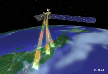 Japanese satellite “DAICHI (ALOS)” with triplet stereo imageries by nadir, forward, and backward (©JAXA)
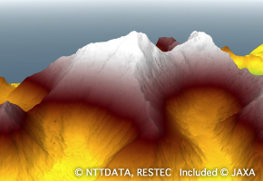 Digital Elevation Model (DEM)
A digital expression of the terrain of the ground surface that has digitized height values in intervals of specific lattice points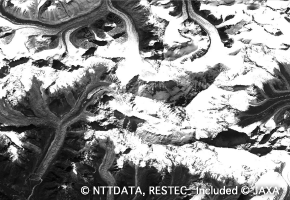 Ortho imagery
Imagery corrected its angle to the data plane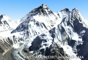 3D Map
3D map overlaying with ortho imagery and DEM
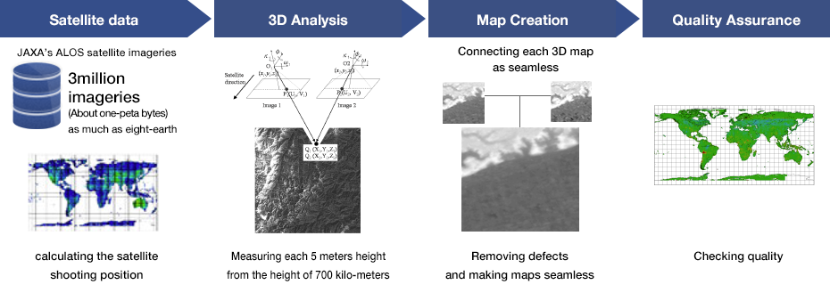
Advanced Image Processing Algorithm x High-performance Data Processing System
Satellite imageries acquired by DAICHI were processed to 3D map with the advanced image processing algorithm that was co-developed by Remote Sensing Technology Center of Japan (RESTEC) and JAXA; there were 4 stages in this process: 1) preprocessing, 2) 3D analysis, 3) mapping and 4) quality check.
There are more than 3 million images of the entire global land area acquired by DAICHI; it takes extremely long time to process them because total amount of data size of these high-resolution imageries are enormous.
However, the high speed and precise information processing technology of NTT Data enabled commercialization of this map product at a realistic timeline.
By adding further improvements, we were able to process 2,000 set of imageries (2TB) per day through parallel processing on the server.
Even with this high-performance system, it took about 2 years to complete processing and verify worldwide data.
Finally, the world’s first global 3D map with 5m resolution, AW3D, was released in 2016.
Strict Accuracy Management throughout the World
We conducted the evaluation of our 3D map accuracy by comparing with the reference of other satellites and ground truth.
Our data was compared with more than 4,600 verification ground points. The result shows that the height accuracy is 3m (standard deviation).
This accuracy is more than sufficient to adopt the map as the fundamental geospatial data that can be used for disaster prevention and other applications.
There are many places in the world where even 2D map is not available, but AW3D offers high accurate 3D map everywhere on the entire global land area.
This will meet new demands of a simulation, survey, and research of natural resources, environment, disaster prevention and traffic on a global scale.
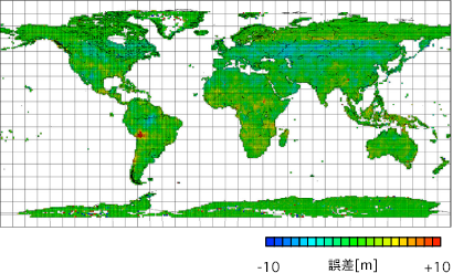 Verification result over the entire area: Mean errors within 3.4m
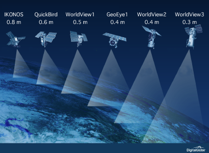
Ultra-high Resolution 3D Map from Multiple Satellites
5 m resolution DEM is good enough to understand terrain, however higher resolution is preferred in some applications. For example, knowing finer undulation is essential to perform sunlight simulation in urban area.
In order to meet our customer’s demand, we collaborate with Maxar Technologies, a US based company who operates one of the world’s highest resolution commercial earth observation satellites, and provide higher resolution 3D map based on 30cm resolution imageries taken with their WorldView satellite series.
This high resolution 3D map is materialized through a technical innovation including processing imageries in multiple angles taken with various high performance satellites.
Thanks to this technological innovation, the accuracy of the 3D Map is successfully improved to the level where one tree can be identified.
There are one standard and two made-to-order products we’ve added to our AW3D lineup; 1) AW3D standard-available entire world DEM in 5m resolution, 2) AW3D enhanced-higher resolution DEM up to 0.5m to 2m, and 3) AW3D building-dataset includes shape and height of buildings.
 Maxar Technologies satellites Constellation (WorldView and others)
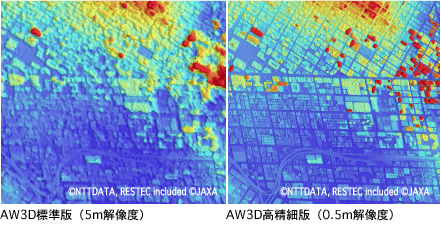 Comparison between 5m and 0.5m DEM in urban area. You can distinguish buildings and roads clearer in 0.5m.
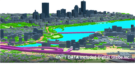 The cityscape of Boston – rendered with AW3D Building 3D data. The delicate details of the buildings, bridges, and vegetation are captured.
Transforming from a browsable map to a valuable map through technical collaboration
AW3D has been developed to pursue the concept of transforming a browsable map to a valuable map.
5m resolution global 3D map used to be too expensive for most business applications, but combination of satellite technology of JAXA, image analysis skill of RESTEC, and data processing performance of NTT Data makes it affordable and practical.
In addition, we convert ultra-high resolution satellite imageries from Maxar Technologies to a valuable 3D map for our customers.
Currently, technological development of AW3D has been driven to focus on providing more value-added information as a part of total solution which links the customer’s business applications.
Developing and providing a solution with the 3D map that can be practically used in customers’ specific operations leads to success of business, such as providing a real-time flood disaster monitoring functionality integrated to a global hydrological cycle change observation system, or a wind-power plant development plan integrated to a wind analysis software package.
These applications are currently being developed on a made-to-order basis, and we are preparing to fully commercialize them with our knowledge and experience.
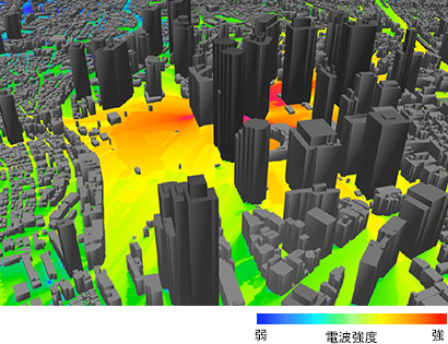 Signal propagation simulation on AW3D data