【Disaster study】Namibia|AW3D Standard DSM (2.5m)
3D kinematic model of the structurally complex Naukluft mountains helps mitigate seismic hazard
Department of Earth and Planetary Sciences (EPS), McGill University
For the research of mitigating seismic hazards, McGill University selected "AW3D” because of its high accuracy and resolution even its competitive price.
The Naukluft mountains in Namibia are a fossilized continental thrust system. Such systems usually develop within the foreland basins of active mountain belts formed along convergent plate boundaries. Such areas are often densely populated, full of infrastructure, fields, and economic centers and are exposed to seismic hazards. A good example would be the Zagros fold and thrust belt, or the Himalaya. These systems also host significant oil and gas resources. Hazard mitigation requires the better understanding for the three-dimensional structure of these tectonic systems, their seismic behavior and evolution. High resolution AW3D data provided the opportunity to reach this goal.
Using the data from AW3D and field mapping, a 3D model of the structurally-complex areas of the Naukluft mountains was produced. This 3D model is used to explore nappe architecture, fault connectivity, and relative timing of faults across various scales. The results shed light on thrust evolution in compressional orogens and the role of earthquakes controlling fault strength.
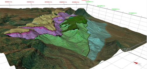
Geological map of the area surrounding Olive Trail, in the south of the Naukluft mountains, generated by Petroleum Experts’ MOVE software using the elevation data from AW3D. Field of view is 4 by 5 km2.

Geological map of the Naukluft mountains (Hartnady, 1978), draped on top of the elevation data from AW3D. Field of view is 15 by 15 km2.
Cooperation/Reference/Data source
Department of Earth and Planetary Sciences (EPS), McGill University
https://www.mcgill.ca/
Pacific Geomatics Limited
https://pacgeo.com/