【Earthquake analysis】Pakistan|AW3D Standard
2013 Balochistan (Pakistan) earthquake analysis using three-dimensional displacements
University of Oxford and Sun Yat-sen University
AW3D Standard Level2 DSM (1,274 sq.km) was used for the earthquake study by scientists at Sun Yat-sen University and the University of Oxford. The DSM was used as ‘pre-earthquake’ topography by combining with the ‘post-earthquake’ dataset of Pleiades digital elevation model, to retrieve 3D displacement fields in the 2013 Mw 7.7 Balochistan, Pakistan, earthquake.
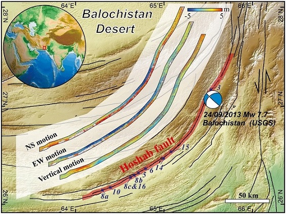
Regional map of the 24 September 2013 Mw 7.7 Balochistan, Pakistan, earthquake
To improve the understanding of earthquake physics and hazards, it is necessary to be able to get the 3D displacements including both the far field and near field. Utilizing light detection and ranging (LiDAR) topography has been a valuable tool, but it is relatively expensive and ‘pre-earthquake’ dataset is always limited. Therefore, they selected the AW3D Standard; which is an off-the-shelf product of high resolution and accuracy, and can be delivered quickly at affordable price.
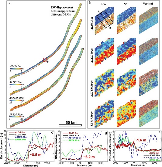
Comparison of 3-D surface deformation derived from AW3D and other DEMs
Please check the details of this study by Yu Zhou et al., 2018 “Characterizing Complex Surface Ruptures in the 2013 Mw 7.7 Balochistan Earthquake Using Three-Dimensional Displacements” at https://agupubs.onlinelibrary.wiley.com/doi/full/10.1029/2018JB016043
AW3D is contributing to the sustainable development of society by providing affordable and high-quality datasets for this kind of advanced researches and studies.
Cooperation/Reference/Data source
Department of Earth Sciences, University of Oxford
https://www.earth.ox.ac.uk/
Sun Yat-sen University
http://www.sysu.edu.cn/