- Others
【Archaeology】Lebanon | AW3D Enhanced
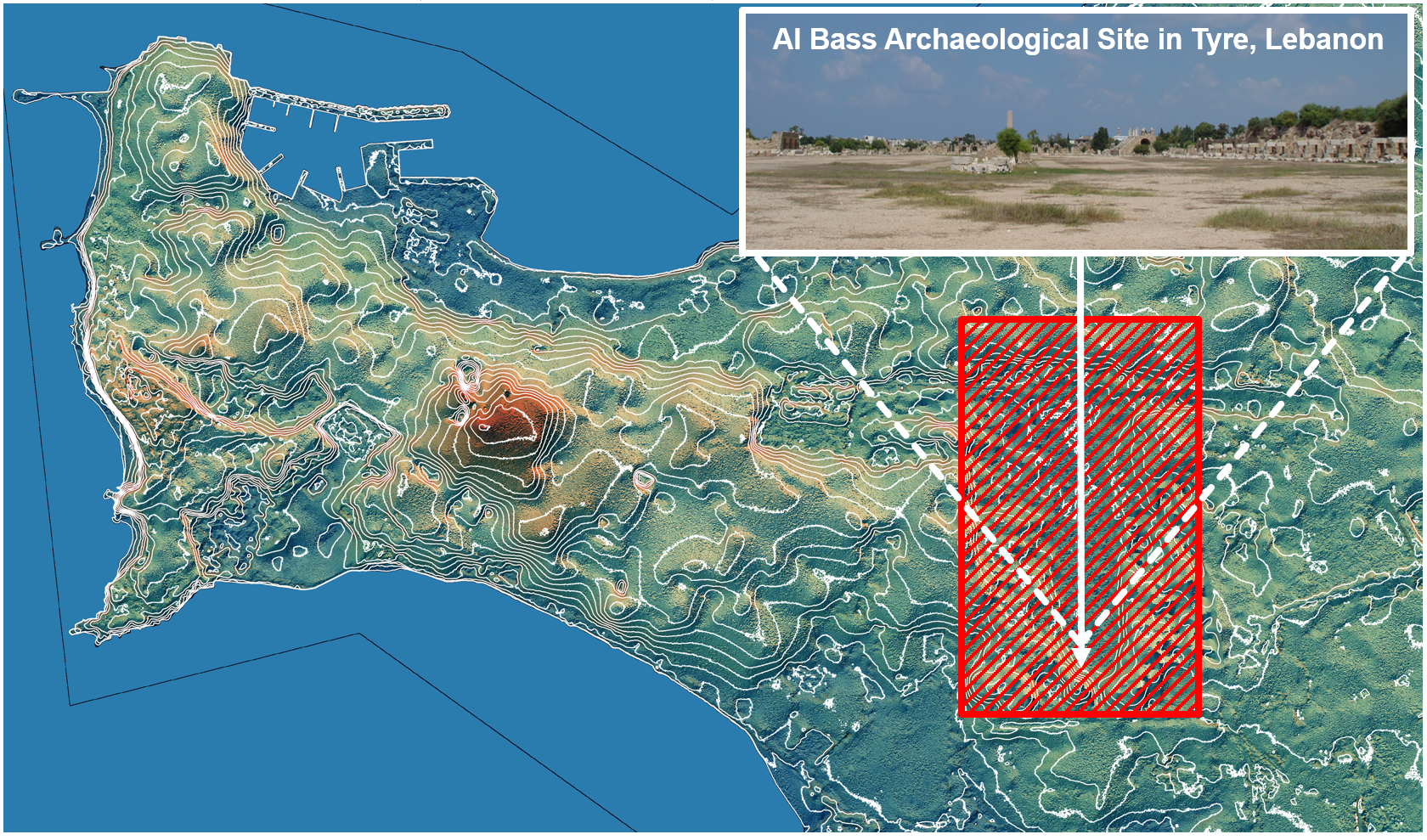
Archaeological Research of Buried Mausoleums in Conflict Are…
Remote sensing plays a crucial role in modern archaeological research. Slope and Aspect, calculated from AW3D ...
Show details
- Others
【Agriculture】Egypt | AW3D Enhanced DTM (0.5m/1m), AW3D Standard DTM (2.5m)
Agricultural Land Consolidation and Irrigation along the Nil…
Increasing agricultural productivity in Egypt is an essential topic to improve lives and livelihoods, and flou...
Show details
- Natural Resources/Mining
【Mining】Worldwide | AW3D Standard
Mapping of geological structures for mining exploration
For mining companies, it is critical to understand the terrain using accurate digital terrain models in the ea...
Show details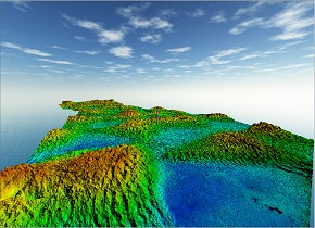
- City Planning/Infrastructure
【Pipeline】The Grand Erg Desert, Algeria | AW3D Enhanced DTM (1m) , AW3D Ortho (50cm), Contour Line (1m)
Pipeline Routing Selection in the Grand Erg Desert, Algeria
JGC Algeria S.p.A (“JGC”), one of the biggest oil and energy companies in Algeria and North Africa, leveraged ...
Show details
- Others
【Health】Bangladesh, Pakistan | AW3D Enhanced DTM (2m)
Tracking of “COVID-19 and other enteric diseases” by studyin…
Dr. Mami Taniuchi, an infectious disease researcher from the University of Virginia, and collaborators from ic...
Show details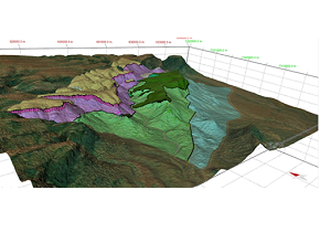
- Disaster Mitigation
【Disaster study】Namibia | AW3D Standard DSM (2.5m)
3D kinematic model of the structurally complex Naukluft moun…
For the research of mitigating seismic hazards, McGill University selected "AW3D” because of its high accuracy...
Show details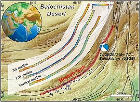
- Disaster Mitigation
【Earthquake analysis】Pakistan | AW3D Standard
2013 Balochistan (Pakistan) earthquake analysis using three-…
AW3D Standard Level2 DSM (1,274 sq.km) was used for the earthquake study by scientists at Sun Yat-sen Universi...
Show details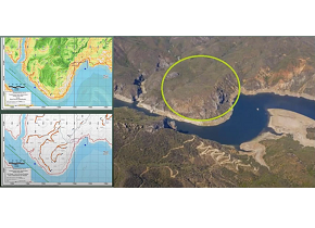
- City Planning/Infrastructure
【Civil engineering】Mexico | AW3D Enhanced
Preliminary design for mining site access road in Mexico
Cambria Geosciences Inc. is a civil engineering consulting firm in Canada, and they were going to conduct a fi...
Show details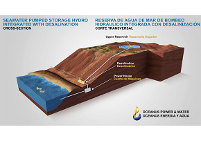
- Disaster Mitigation
【Flood simulation】LATAM | AW3D Enhanced
Safety design around the integrated pumped hydro reverse osm…
Oceanus Power & Water is an advanced company that provides an integrated system combining a pumping-up pow...
Show details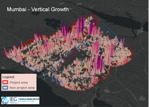
- City Planning/Infrastructure
【Urban planning and assessment】India, Mozambique | AW3D Enhanced
Urban spatial growth analysis
Independent Evaluation Group (IEG) of the World Bank leveraged AW3D for urban spatial growth analysis. The pro...
Show details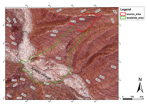
- Disaster Mitigation
【Landslide analysis】Shichuan, China | AW3D Standard
Landslide runout distance simulation using AW3D Standard DSM
The catastrophic large-scale landslide triggered by rainfall, destroying 40 houses and killing 118 people in X...
Show details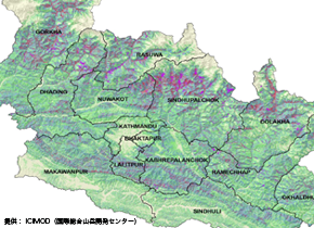
- Disaster Mitigation
【Disaster prevention】Nepal | AW3D Standard
Hazard map for long-term reconstruction plan after the major…
Nepal has many steep mountains, and measures against natural disasters related to such terrain characteristic ...
Show details
- Natural Resources/Mining
【Mining】Worldwide | AW3D Standard
Efficient and time-saving mineral exploration in its early s…
Efficient mineral exploration in remote location such as the Andes (South America) is very challenging task. T...
Show details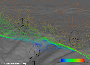
- City Planning/Infrastructure
【Power Plant】Inside and outside of Japan | AW3D Standard
Selection of Wind Turbine Best Location
Mountainous areas in Japan have complicated topography. This might cause wind turbulance which may adversely ...
Show details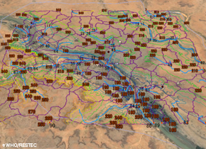
- Others
【Health】Nigeria, Niger | AW3D Standard
Identification of “poliovirus infection route” by studying s…
Nigeria, Pakistan, and Afghanistan are registered as polio ever-present countries. WHO samples surface sewage ...
Show details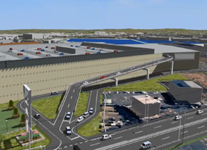
- City Planning/Infrastructure
【Urban planning】Japan | AW3D Building
Estimating environment impact on building a big shopping mal…
When planning large-scale shops in urban areas, it requires to estimate how the development would affect and f...
Show details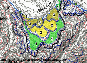
- Disaster Mitigation
【Disaster prevention】Vietnam | AW3D Standard
More than 1,000 hazardous locations were pointed out on Nati…
Necessity of landslide disasters prevention on the road network of the mountainous area in Vietnam. Difficulty...
Show details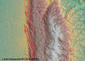
- Disaster Mitigation
【Disaster prevention】Myanmar | AW3D Standard
Active faults study in nation wide area
Necessity of active faults distribution study for earthquake preparation in Myanmar. Difficulty of aerial phot...
Show details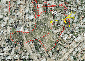
- Disaster Mitigation
【Disaster prevention】Honduras | AW3D Enhanced
Demonstration of extracting landslide hazard area in urban c…
Tegucigalpa, the Capital of Honduras is surrounded by mountains and the landslide disaster caused by urban dev...
Show details
- Disaster Mitigation
【Disaster prevention】Sri Lanka | AW3D Standard
Evaluation of “the whole aspect of the landslide disaster da…
The landslide disaster occurred on Oct. 29th 2014, which was the largest scale ever recorded. JICA conducted t...
Show details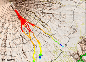
- Disaster Mitigation
【Disaster prevention】Indonesia | AW3D Standard
Route simulation of volcanic pyroclastic flow
Semeru Volcano eruptions have been caused serious damages. Especially, it had casualties due to gas and roc...
Show details