【Mining】Worldwide|AW3D Standard
Mapping of geological structures for mining exploration
Geosense
For mining companies, it is critical to understand the terrain using accurate digital terrain models in the early phases, followed by site selection, and route design to the site.
Geosense provides value-added data for many mining users who need to understand the structural controls of possible ore bodies or oil/gas fields in the exploration phase. The phase is one of the most important phases as it affects the efficiency and effectiveness of the following phases (e.g. planning and designing, development, operation, and closure).
In the exploration phase, the mapping of geological structures with terrain data is often carried out in phases, first a preliminary regional mapping phase, followed by more detailed mapping of a smaller area that is of particular exploration interest. During the detailed mapping phase, it is important to understand the small structures that control mineralization at the local level.
Generally, the budget for the mapping of geological structures is limited. Therefore, Geosense had been using free terrain datasets such for the regional mapping phase, such as SRTM and ASTER GDEM. However, the accuracy of the free datasets (about 10m RMSE) was not good enough for the site selection and the route design. Thanks to its accuracy, the reasonable price, and global coverage, Geosense’s preferred DSM for the detailed mapping phase is 2.5m/5m resolution AW3D Standard (5m RMSE/7m LE90).
Geosense was able to load the AW3D Standard datasets into the GIS software (e.g. QGIS, TNT Mips, and ArcGIS) smoothly, create a shade raster from the DSM, and start mapping immediately without large investments that would be required for many competing DSM datasets.
Siebe Breed, Structural Geologist & Geological Mapping Consultant of Geosense commented that
“We are satisfied with AW3D's quality and reasonable price. And we always receive valuable information from Pacific Geomatics before ordering data. Therefore, it is not difficult to justify the purchase/use of AW3D data within Geosense”.
He also mentioned that Geosense would continue to use AW3D for further projects.
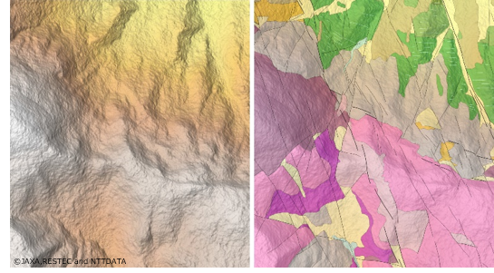
Mapping the type of geological information with the AW3D DSM data (5m)
Cooperation/Reference/Data source
Geosense
https://www.geosense.nl/
Pacific Geomatics Limited
https://pacgeo.com/